Table of Contents
Mobile Network Towers
Canadian Government / Regulator
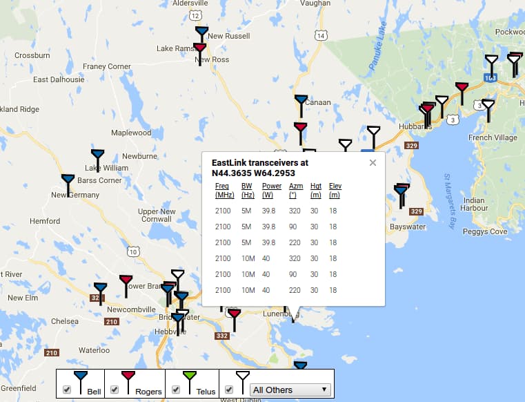 The Canadian regulator publishes a downloadable, Comma Separated Value (CSV) file with the location of every tower in Canada together with information about the operator(s) on the tower as well as the type of equipment, power output, antenna orientation, etc. This is all you could want to build a comprehensive map of towers across Canada and indeed someone has done so. Steven Nikkel has imported that information into an online map that provides a brilliant picture of mobile infrastructure in Canada. This is enormously handy information for the average citizen trying to choose a service provider in any region outside of a major urban centre where coverage varies significantly between operators. There is no reason not to do this sort of mapping everywhere. We just need to explode a few myths and change the norms around publishing tower data.
Netherlands Antenna Register
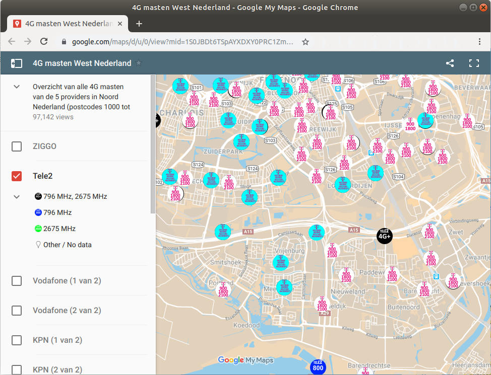 Dutch regulations mandate that any permanently installed antenna installations with a transmitting power greater than 10 decibels Watt (dBW) must be documented in a public data resource. This information is held by the Telecom Agency and can be found as map of towers. This information is enhanced through the addition of operator information at antennekaart.nl which breaks down towers by operator as well as providing more general information on spectrum. Information recorded includes:
| Tower Info | Antenna Info (each) |
|---|---|
| Service Type | Height |
| City | Main beam direction |
| Date of issue | Frequency |
| Date of commissioning | Power output |
| Main type | Safe Distance |
| Latitude | |
| Longitude | |
| Postal code | |
| Id |
Swiss Government
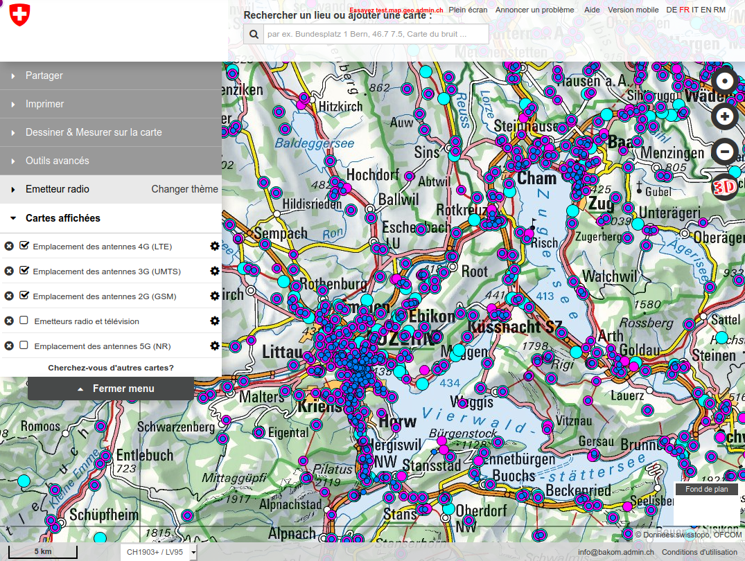 The Swiss government maintain extensive maps of both telecommunications and broadcast infrastructure in Switzerland. This includes a map of all radio tower infrastructure, 2G/3G/4G/5G towers as well as broadcast towers. Power output is also captured as well as microwave links between the towers. They also have a 4G coverage map. All the day is available in WMS layers which means it can be integrated with other GIS sources.
–
Airtel India
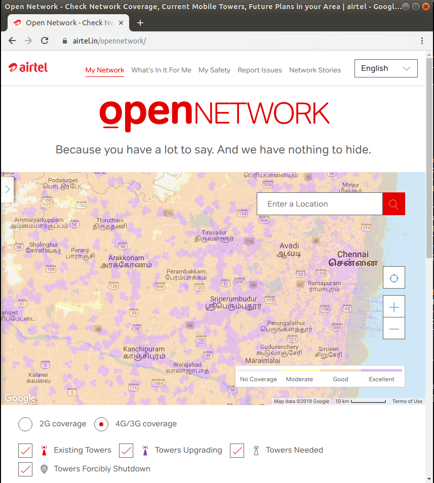 In India, veteran operator Airtel have published a new website entitled Open Network in which they map all of their towers for both 2G and 4G networks, as well as identifying where towers are being upgraded and where they are needed. The website goes by the slogan “Because you have a lot to say. And we have nothing to hide”. This is strong evidence to illustrate how transparency, far from being a liability, can actually be a powerful tool for marketing. This is the first instance of a commercial operator publishing tower locations.
–
Airtel Uganda
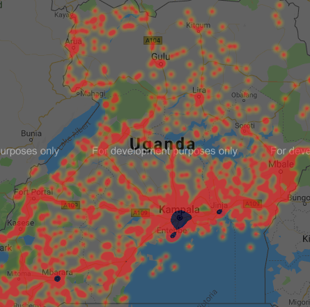 Following the example of their parent company, the Airtel Uganda website now contains a map of Airtel towers across Uganda, making them the first mobile network operator on the continent to publish a map of their towers.
–
Airtel Nigeria
ARCEP France
 The French regulator, ARCEP (Autorité de régulation des communications électroniques, des postes et de la distribution de la presse), has an excellent resource entitled the Tableau de bord du New Deal Mobile or New Deal Mobile Dashboard which includes datasets with details of all mobile towers as well as coverage and planned 4G coverage maps. All data is freely downloadable in an open (CSV) format, under an Open Data license.